Now that I’ve been doing this a few days I can say that there are days where a long time goes by and you’re not quite sure what you’re going to write about.
Today was not one of them.
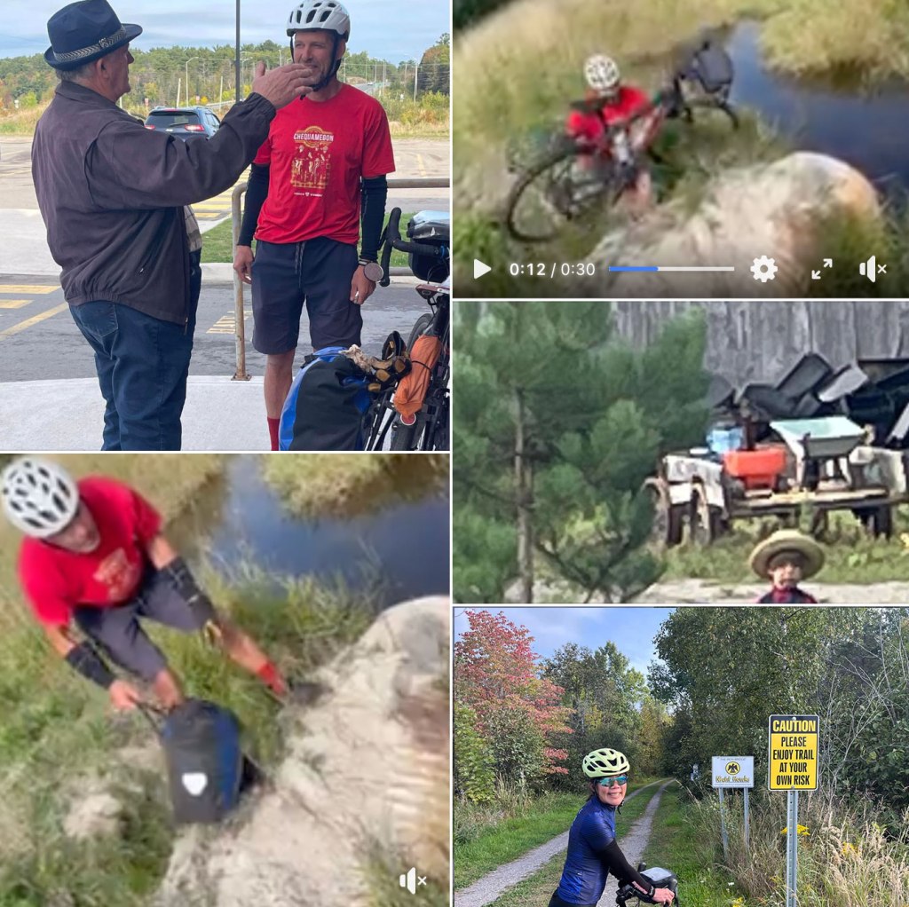
As soon as we left Tim Horton’s – after a surprisingly good breakfast – I met Chuck. Chuck used to ride a lot when he was young. He lived 50 kilometers from his foster-mother, but would bike both ways to visit her – with both front and rear packs on his bike, which was a three-speed with upside down handlebars because you “could really pull yourself up a hill with them like that.” He would bring tubes and tires and he traveled with a fishing rod and a shotgun. He brought the shotgun along because farmers along the way liked it when he would shoot the groundhogs – although Chuck added that he didn’t often hit the groundhogs because if they saw you they would duck down into their den and just their eyes would be sticking up. Chuck misses riding and lamented that he would still be riding a lot if he was 25.
All of this gleaned from one minute of conversation.
Canadians are certainly friendly and fun!
Who remembers what I said just two days ago about Diana and me not trusting Google Maps for bikes? Apparently not us . . .
Before we talked to Chuck we sat in Tim Horton’s and considered our options for the day. This gets a bit convoluted, but stay with me . . . It turns out to be important to our day . . .
First off, while we acquired maps that were better than an Ontario-wide map, we still don’t have the maps you really need to navigate on bicycles well. You just can’t see what the various roads mean when the scale is this small . . .
We learned yesterday that we liked the Great Lakes Waterfront Trail – it mostly avoids the Trans Canadian Highway and it takes you on some great backroads. But there are two problems with the Waterfront Trail. The first is that there is no Waterfront Trail app – meaning that to use the trail your only option is to follow the signs. The second is that we were planning to bite off a pretty good chunk today, and the Waterfront Trail tends to go out of its way to go into towns – which we didn’t necessarily want to do today because we were already going pretty far for the day.
So we didn’t want to blindly follow the Waterfront Trail today. Now, yesterday we had noticed that Google Maps for bikes seemed to follow the Waterfront Trail, except it didn’t seem to take you into the towns.
Our next deduction was the real crux of the problem. We reasoned that if we just followed Google Maps bike directions we would enjoy the best of the Waterfront Trail without the added distance of the forays into the towns.
Diana looked at some of the trails on our road atlas map. The pictogram indicated “seasonal use roads.” I told Diana that just meant that they were not maintained in the winter.
And so we decided to go with our new strategy – follow Google Maps for bikes for the day.
I guess some people never learn!
So we headed out – fresh off our refreshing conversation with Chuck.
“Turn right in 200 meters,” Google Maps started out.
“Turn right,” it continued.
All seemed great. There was Lake Huron. Another great day had begun.
“Make a left turn,” Google Maps intoned.
We paused. There was a sign saying: “CAUTION: Please Enjoy Trail At Your Own Risk.”
This led to a brief conference.
“Is this really what Google Maps wants us to do?”
“Yes, but it doesn’t look very long and it actually looks like a pretty nice trail.”
So we headed out.
The next sign said that we were in bear country and should be careful, or something like that . . . We laughed this one off as well . . .
Soon we were taking pictures of each other navigating a fun double-track through the woods, thinking we were paying homage to the folks back home doing the Chequamegon. This was good.
And the sirens of Google Maps for bikes slowly sucked us in. A nice double track to begin. One puddle next – still pretty quaint really. And then a little more muddy, but still do-able.
And by this time we were too far down the path. There was no going back now . . .
And then we arrived at the culvert. Culvert is probably not a good description I guess. Yes, there was a culvert there. But the swamp had completely defeated it – leaving a chasm, a culvert, and then another chasm. And this was no 6” culvert. This was about 4’ in diameter, with 4’ deep chasms . . .
Being past the point of no return there was no option now. We could only go forward. And it looked like we would be done with the trail soon – according to Google Maps.
Believe me when I say this was not a pretty scene. We had to take the panniers off the bikes and throw them over the chasms and the culvert individually. Then I had to find a way to move the bikes onto the culvert while standing in the chasm (whose bottom was swamp), then move to the next chasm and move the bikes across to the “trail” on the other side.
Diana was not amused. Or rather, at this point she was still a little amused. Fortunately for me, this plan of following google maps had been hatched as much by Diana as by me.
Otherwise I’m not sure I would have survived the day to be writing now . . . (Is there a name for the killing of one’s husband? Patricide or something?)
And so we continued on.
Soon we were going over logs, around puddles, through brambles, stinging nettles and biting grass up to our hips, and then, inevitably, through puddles, and then through things that can only be described as mud pits.
Not good.
Finally we emerged onto a gravel road.
I was pretty happy at this point. I had dodged a bullet. Diana was still in relatively good humor. The bikes were still functioning. And I was still alive. (Admittedly, my happiness threshold standards might have eroded a little this morning . . . like the chasms around the culvert . . .That’s the good thing about doing really horrible things – they make you realize how good you really have it . . .)
But speaking of bullets I have another bone to pick . . . 400 or so miles ago we went through Park Falls, Wisconsin, which claimed to be the Grouse Capital of the World. Now we were in the Park Falls for quite a while – what with camping there and the flat tire business. Didn’t see a single grouse. No drumming. Nothing.
And then in a few minutes in the woods this morning I scared up two grouse. Grouse capital of the world, indeed.
But the other thing this episode made me realize is that maybe I need to take a page from Chuck’s book and ride with a shotgun. I mean, let’s say we got stuck on this trail? Or a bear attacked? I mean I could have shot those grouse and then we’d have dinner. And maybe I’d get a better survival rating then . . . On this note, I did stop to take a picture of a giant mushroom as well. Who knows when you’ll need to eat a wild mushroom to survive? And, after all, we had a doctor with us – even if she isn’t licensed in Canada.
All this was going through my mind as we headed out on the gravel road – which would take us back to the Trans Canadian Highway . . . and civilization.
Except it didn’t.
“Take a left turn,” squawked Google Maps.
And there it was: another trail into the woods . . . And there was DEFINITELY no going back now. What were we going to do? Go back over the chasms and culvert? No way!
So we headed down this trail – which, like the last one, became steadily more impassable as we went – until we reached a gate across a bridge with a sign reading: “No Horses” – with a pictograph showing a horse with a line through it.
And now I’m lifting the bikes over the gate. I mean, the bikes are not horses – so they’re clearly allowed.
And then the trail becomes essentially one long bog. Did I mention that Diana HATES getting her feet wet? Also hates brambles and scratching grass.
I am becoming very afraid . . .
And then I hear “Waaah Aaaaaah!” from behind me.
The thing with Diana’s cry of distress is that it is equal opportunity. Break her nail: “Waaah Aaaaaah!” Fall to her death: “Waaah Aaaaaah!” There is no distinction. So for all I know a bear has just emerged from the woods and eaten her leg (I doubt it would eat more. I would think Diana would be tough and stringy – would have to be a pretty hungry bear to eat more . . .).
I rush back. Now I’m really going to be in trouble. But Diana, being Diana, is already up. These are gravel bikes – so they are okay with a little bit of tougher stuff – but these tires are not made for this and they’re inflated to about 60 psi – so Diana wheel was sucked into a rut and she fell. Diana mutters something about more whiplash systems, but she is not one to linger over her wounds. Off we go again . . .
Fortunately, I soon reach the end of this trail . . .
As I wait for Diana I see a sign on this end of the trail saying: “No Trespassing. Violators will be Prosecuted.”
All I can say is that Google is going to pay this bill.
But we are done with Google’s trail. And I realize that in Canada a Seasonal Use Road means a road that is only maintained in winter, not summer. Because, let’s face it, up here winter lasts longer than summer. Of course seasonal use means winter . . . Maintenance probably means driving a groomer down the trail after 52 feet of snow falls – enough to hide the potholes, logs, and other “blemishes” on the trail.
We won’t mention that error on my part just yet . . .
We finally get back to the Trans Canadian Highway. It’s been two hours since I talked to Chuck. And there’s a sign for Tim Horton’s saying it is only five kilometers away. Google Maps – you suck!
But back to the Trans Canadian Highway (TCH). This is a terrible road for bikes. Lots of big semis. No shoulder. Like, really, no shoulder. And what is there is crumbling so you might fall off and crash at any moment. But at least the speed limit is 90!
At this point Diana doesn’t care about any of that. (I mean, under normal circumstances Diana will bike on interstates, so this really isn’t that big of a leap . . .)
“I don’t want to risk being on another trail like that one!” she says.
So we head down the shoulder-less TCH. She feels safer on this “Mad Max Thunder Dome” road then she did on the Google Maps trail. What can I do? There is no arguing now . . .
So off we go.
Thank goodness there is a Great Lakes Waterfront Trail sign about a kilometer down the road – telling us to head off to the right. And soon we are enjoying another blissful day full of riding in Mennonite territory.
We see Mennonite children playing in a sandbox – complete with bonnets for the little girls and hats for the little boys. We see another chariot of death – this time driving on the TCH itself; these people have no fear. Kind of funny – he has an old mattress in the back. We see (and hear) a Mennonite man operating a sawmill. He waves merrily.
And this causes Diana – who is maybe not her most generous self at this point – to question what is going on with these people – particularly the men. They seem to use electricity whenever they want. Meanwhile, there are laundry lines a mile long full of garments that the women-folk wash and dry by hand. Probably the electricity to power the sawmill comes from the wives in the back room pedaling furiously on generator connected exercise bikes . . .
And every house we bike by has a list of things for sale, with the laundry lines acting like a great marketing tool. They don’t need to say they are Mennonites. That would be crude and would not generate sales. Instead, let the passerbyers infer that we’re Mennonites because we have a mile of laundry on the line and we have children playing in the sandbox with bonnets and hats. That’s the kind of quaintness that will generate sales . . . (Maybe the U.P.ers need to hire the Mennonites to do their marketing. Hello, Mr. Bates Motel!)
But enough bitterness about Mennonites. Diana eventually recovered, we made it to the campsite, where there was a beautiful river to swim in and there was laundry with a dryer.
Another great, if interesting, day in the books.
Might be worth glancing through the pictures and videos today. They might tell the story better than I could anyway . . .

Leave a comment